|
Origin of the
buried valleys
The buried valleys are predominantly formed as tunnel
valleys underneath the glacier ice during the ice ages. With respect to
morphology and dimensions the mapped buried valleys are
comparable with open tunnel valleys found in the present-day
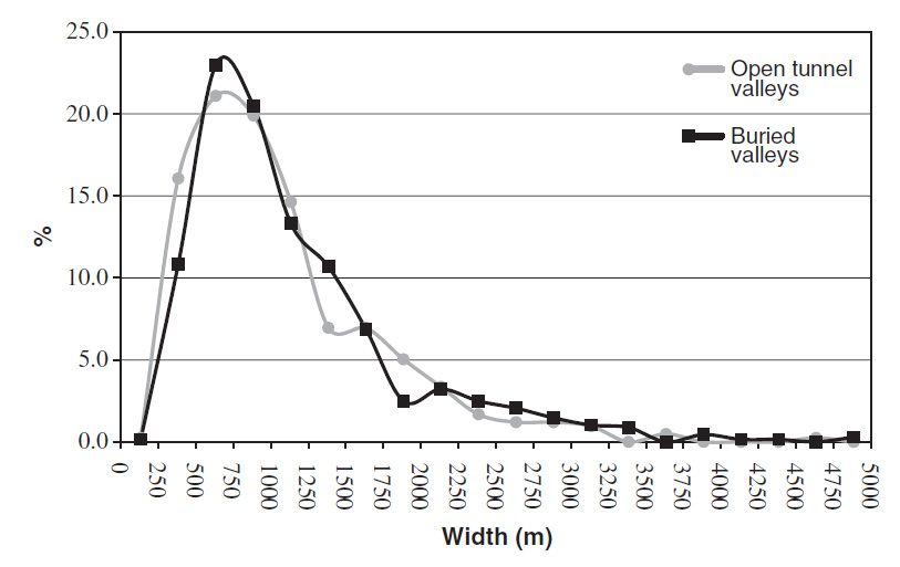
Danish landscape (see Figure to the right).
The valleys were mainly eroded by meltwater supposed to have drained from subglacially stored reservoirs, probably behind a frozen margin. The water was most likely released in repeated jokulhlaups and flowed in relatively small channels on the floors of the tunnel valleys, which gradually became ice-filled with the lowering of the bed. Selective linear, glacial erosion is also believed to have contributed to the erosion. This, however, was most pronounced for the widest valleys and is supposed to have played a secondary role.
Tunnel valleys/buried valleys have a
tendency to be re-used during the repeated cycles of
glaciation producing separate valley generations and multiple cut-and-fill structures.
The mapped buried valleys vary in depth with the deepest
features exceeding 350 m. The width is generally between 0.5 and
1.5 km, but widths of up to 4 km occur (see Figure, upper right). The lengths of the
valleys are difficult to evaluate, because many of the
surveyed areas are small. However, the length of some valleys in
larger survey areas exceed 25–30 km. Striking features of the
valleys are that they often terminate abruptly and that they are
highly irregular with depressions and thresholds along the
valley floors.
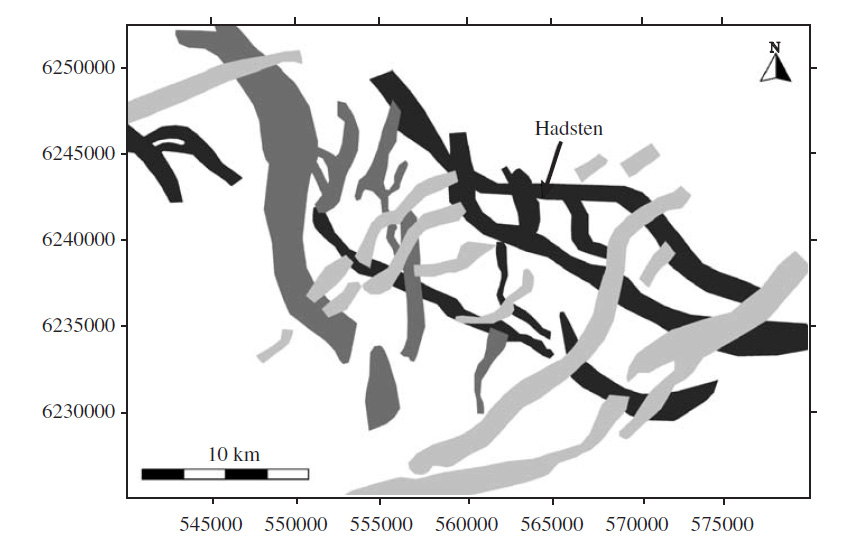
The buried valleys
can be divided into different generations that were formed underneath
glaciers during the Quaternary glaciations (see Figure, middle right). The valleys often
cross-cut each other and sometimes have varying preferred
orientations. A complicated pattern with three to five
generations of valleys can often be distinguished in areas with
high data resolution. If the ice flows were parallel or
near-parallel to pre-existing valleys in the subsurface, these valleys would be
liable to repeated erosion and re-filling producing a
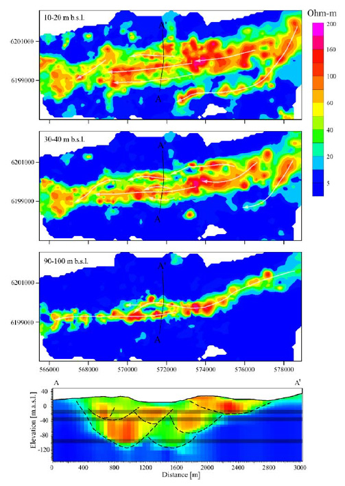
complicated cut-and-fill setting within the valleys. Multiple
generations of valley erosion are therefore often found within
the buried valleys themselves (see Figure, bottom right). The valley architecture is
normally complex due to this cut–and–fill history, but also due
to glaciotectonic disturbances. This complexity can be observed
in both seismic data and TEM data. The complex fill is also
often indicated by borehole data that show strong lithological
variations over short distances.
The valley fill is deposited in sub-glacial and pro-glacial
environments. Statistical analyses of borehole data in all the
mapped valleys show that by far the most common infill sediment
types are tills and meltwater deposits. In this group, 52% are
coarse meltwater deposits (sand and gravel), 30% are clay-rich
till and 18% are fine-grained meltwater deposits (silt and clay).
The buried tunnel valleys are isolated features which are not
interconnected in anastomosing systems. It is unclear whether
all valleys in each generation were formed simultaneously or if
the individual valleys were formed separately. It is however
evident, that many tunnel valleys became ice-filled by creeping
ice following the erosion of the bed. Steady subglacial
meltwater flow or recurring meltwater releases may continuously
have eroded deeper into the substratum followed by ice creep
closure of the meltwater channels during periods of decreasing
meltwater pressure.
It is difficult to determine the ages of the buried valleys. The
infill sediments can be dated in some cases, but this is not
necessarily the time of valley erosion. However, based on the
time gap between the age of the eroded sediments and the age of
the infill sediments, some of the buried valleys can be shown to
have formed during the Weichselian, the Saalian and the
Elsterian glacial stages. Some of the valleys were probably
formed during older glacial stages.
|

Width of open tunnel valleys vs. buried valleys (From Jørgensen & Sandersen 2006)

Three buried valley generations NW of the city of Aarhus (From Jørgensen & Sandersen 2006)

Selected resistivity maps and a cross section of a selected buried valley at Boulstrup-Hundslund (From Jørensen & Sandersen 2006)
|

